List of street namesakes: Difference between revisions
Jump to navigation
Jump to search


Philvarner (talk | contribs) No edit summary |
mNo edit summary |
||
| Line 5: | Line 5: | ||
The system of numbering the streets is somewhat similar to the Washington plan. Each block represents 100 numbers, whether heading east, west, north or south. The city is divided into four sections.<ref>https://babel.hathitrust.org/cgi/pt?id=uva.x000196692&view=1up&seq=33</ref> | The system of numbering the streets is somewhat similar to the Washington plan. Each block represents 100 numbers, whether heading east, west, north or south. The city is divided into four sections.<ref>https://babel.hathitrust.org/cgi/pt?id=uva.x000196692&view=1up&seq=33</ref> | ||
:'''Fifth''' – South of 500 W Main Street | |||
:'''First''' – North of East Main and East of North First, or Northeast | |||
:'''Second''' – South of East Main and east of South First, or Southeast | |||
:'''Third''' – North of West Main and west of North First, or Northwest | |||
:'''Fourth''' – South from 402 West Main | |||
:'''Sixth-and-a-Half''' – South from 606 Dice | |||
:'''Seventh-and-a-Half''' – South from 620 Dice | |||
:'''Main''' – The dividing line between north and south streets, runs east from First to [[C & O Lower Depot]] and west from First to University. | |||
:'''First''' – The dividing line between east and west streets, runs north and south from Main to city limits. | |||
:Main – The dividing line between north and south streets, runs east from First to C & O Lower Depot, and west from First to University | |||
::The main Chesapeake and Ohio Railroad Station, being located under the present day [[Belmont Bridge]]; | |||
:First – The dividing line between east and west streets, runs north and south from Main to city limits | |||
==(A)== | ==(A)== | ||
*[[Ackley Lane]] | *[[Ackley Lane]] – unknown | ||
*[[Agnese Street]] | *[[Agnese Street]] – unknown | ||
*[[Ainsley Alley]] | *[[Ainsley Alley]] – unknown | ||
*[[Albemarle Street]] | *[[Albemarle Street]] – as with [[Albemarle County]], named for [[Willem van Keppel]], 2nd Earl of Albemarle | ||
*[[Alderman Road]] | *[[Alderman Road]] – [[Edwin A. Alderman]], first President of the [[University of Virginia]] | ||
*[[Allen Drive]] | *[[Allen Drive]] – unknown | ||
*[[Allied Lane]] | *[[Allied Lane]] – possibly Allied Concrete, founded in 1946 and now located near the street | ||
*[[Allied Street]] | *[[Allied Street]] – possibly Allied Concrete, founded in 1946 and now located near the street | ||
*[[Almere Avenue]] | *[[Almere Avenue]] – unknown | ||
*[[Altamont Circle]] | *[[Altamont Circle]] – toponym meaning "high mountain" | ||
*[[Altamont Street]] | *[[Altamont Street]] – toponym meaning "high mountain" | ||
*[[Altavista Avenue]] | *[[Altavista Avenue]] – toponym meaning "high viewpoint" | ||
*[[Amherst Commons]] | *[[Amherst Commons]] – unknown | ||
*[[Amherst Street]] | *[[Amherst Street]] – unknown | ||
*[[Amstel Avenue]] | *[[Amstel Avenue]] – unknown | ||
*[[Anderson Street]] | *[[Anderson Street]] – unknown | ||
*[[Angus Road]] | *[[Angus Road]] – unknown | ||
*[[Antoinette Avenue]] | *[[Antoinette Avenue]] – unknown | ||
*[[Antoinette Court]] | *[[Antoinette Court]] – unknown | ||
*[[Apple Tree Road]] | *[[Apple Tree Road]] – presumably the tree | ||
*[[Arbor Circle]] | *[[Arbor Circle]] – unknown | ||
*[[Arlington Boulevard]] | *[[Arlington Boulevard]] – unknown | ||
*[[Ashby Place]] | *[[Ashby Place]] – possibly Confederate general [https://en.wikipedia.org/wiki/Turner_Ashby Turner Ashby, Jr.] | ||
*[[Augusta Street]] | *[[Augusta Street]] – unknown | ||
*[[Avon Street]] - the River Avon in England, in reference to the birthplace of William Shakespeare, Stratford-upon-Avon, by Bartlett Bolling, the developer of the Belmont subdivision | *[[Avon Street]] - the River Avon in England, in reference to the birthplace of William Shakespeare, Stratford-upon-Avon, by Bartlett Bolling, the developer of the Belmont subdivision | ||
*[[Azalea Drive]] | *[[Azalea Drive]] – "Azalea" estate<ref name=":0">Massie, Frank A., and Virginia School Company. A New and Historical Map of Albemarle County, Virginia. Owned and published by the Virginia School Company, 1907. https://search.lib.virginia.edu/sources/maps/items/u2716440</ref> | ||
==(B)== | ==(B)== | ||
*[[Bailey Road]] | *[[Bailey Road]] – unknown | ||
*[[Bainbridge Street]] | *[[Bainbridge Street]] – unknown | ||
*[[Baker Street]] | *[[Baker Street]] – unknown | ||
*[[Banbury Street]] | *[[Banbury Street]] – unknown | ||
*[[Barbour Drive]] | *[[Barbour Drive]] – unknown | ||
*[[Barksdale Street]] | *[[Barksdale Street]] – The [[Barksdale family]], prominent Albemarle and City of Charlottesville family dating back to the early 1700s.<ref>{{cite web|title=Albemarle County In Virginia|url=https://archive.org/details/cu31924028785703|author=Rev. Edgar Woods|work=|publisher=The Michie Company, Printers |location=|publishdate=1901|accessdate=May 7, 2019}}</ref> Members of the family included a soldier in the Revolutionary war. W. R. Barksdale (1828 - 1912) was in Confederate general J.E.B. Stuart’s command, wounded at the battle of Yellow Tavern in the same engagement in which Stuart was killed. His sons, James Barksdale and John Barksdale, were partners with John Fry to invest in small lots in the neighborhood. | ||
*[[Barracks Road]] | *[[Barracks Road]] – The [[Albemarle Barracks]], a prisoner-of-war camp for British prisoners during the American Revolutionary War. | ||
*[[Baylor Lane]] | *[[Baylor Lane]] – unknown | ||
*[[Baylor Place]] | *[[Baylor Place]] – unknown | ||
*[[Beechwood Drive]] | *[[Beechwood Drive]] – presumably the tree | ||
*[[Belleview Avenue]] | *[[Belleview Avenue]] – unknown | ||
*[[Belleview Street]] | *[[Belleview Street]] – unknown | ||
*[[Belmont Avenue]] | *[[Belmont Avenue]] – from the 551-acre estate sold in [[1847]] at auction to [[Slaughter Ficklin]] who renamed it Belmont from the original Belle-mont. (From an English surname of Norman origin, a variant of the surname BEAUMONT, which was derived from place names meaning "lovely hill" in Old French (from beu, bel "fair, lovely" and mont "hill")). | ||
*[[Belmont Cottage Lane]] | *[[Belmont Cottage Lane]] – named for the [[Belmont-Carlton neighborhood]], itself named for the plantation big house on the Belle Mont Estate, [[Belmont House]] (or Belmont Mansion), much of which is part of the former [[Belle Mont Estate]], though the property this street is was not part of the estate. It is a common place name meaning "beautiful mountain." | ||
*[[Belmont Park (Street)|Belmont Park]] | *[[Belmont Park (Street)|Belmont Park]] – named for adjacent [[Belmont Park]], which itself named for the plantation big house on the Belle Mont Estate, [[Belmont House]] (or Belmont Mansion). It is a common place name meaning "beautiful mountain." [[Belmont Park]] one of the finest neighborhood parks in the City, is bounded by [[Stonehenge Avenue]], [[Rialto Street]] and [[Druid Avenue]]. Plans were finalized in [[1915]] for the establishment of [[Belmont Park]] through donations from [[Paul Goodloe McIntire]], a local businessman and philanthropist. The 3.1 acres of land were bought by McIntire in [[1921]] and he transferred the property to the City to be used as a park and playground for local citizens. | ||
*[[Bennett Street]] | *[[Bennett Street]] – unknown | ||
*[[Berring Street]] | *[[Berring Street]] – unknown | ||
*[[Bing Lane]] | *[[Bing Lane]] – the cherry varietal; intersecting with Rainier Road (another cherry varietal) | ||
*[[Bingler Street]] | *[[Bingler Street]] – unknown | ||
*[[Birdwood Court]] | *[[Birdwood Court]] – [[Birdwood Estate]], owned by the Garth family | ||
*[[Bland Circle]] | *[[Birdwood Road]] – [[Birdwood Estate]], owned by the Garth family | ||
*[[Blenheim Avenue]] | *[[Bland Circle]] – likely the [https://en.wikipedia.org/wiki/Richard_Bland_(burgess) Bland] family, a "[https://en.wikipedia.org/wiki/First_Families_of_Virginia First Family of Virginia]" | ||
*[[Blincoe Land|Blincoe Lane]] | *[[Blenheim Avenue]] – [https://en.wikipedia.org/wiki/Blenheim_Palace Blenheim Palace] in England, of many English place names used by the developer of Belmont, [[Bartlett Bolling]] | ||
*[[Blue Ridge Road]] | *[[Blincoe Land|Blincoe Lane]] – unknown | ||
*[[Bolling Avenue]] | *[[Blue Ridge Road]] – The Blue Ridge Mountains | ||
*[[Bollingwood Road]] - as with Bolling Avenue, [[Bartlett Bolling]] | *[[Bolling Avenue]] – [[Bolling family]] or a specific Bolling; [[Bartlett Bolling]], a member of the Bolling family, one of the founding member of the [[Belmont Land Company]] (later, the [[Charlottesville Land Corporation]]) developted the neighborhood beginning in 1891 and through the early 20th century, Confederate soldier, and neo-Confederate activist. Related by marriage to the second son of General [[Robert E. Lee]] and Mary Anna ''Custis'' Lee, William Henry Fitzhugh Lee (May 31, 1837 – October 15, 1891), also known as W.H.F. Lee. On November 28, 1867, W.H.F. Lee married Mary Tabb Bolling. | ||
*[[Booker Street]] | *[[Bollingwood Road]] - as with Bolling Avenue, [[Bolling family]] or a specific Bolling; [[Bartlett Bolling]] | ||
*[[Booker Street]] – possibly [[Booker T. Washington]] or [[Rev. George E. Booker, D.D.]], originally ''Brook Street'' (ca. 1916) | |||
[[File:1916 - Stewart Fuller aka Stuart Fuller.JPG|thumb|400px|In 1919, [[Stewart Fuller]] lived on '''Booker Street''' with his parents, Stewart & Alberta ''Douglas'' Fuller.]] | [[File:1916 - Stewart Fuller aka Stuart Fuller.JPG|thumb|400px|In 1919, [[Stewart Fuller]] lived on '''Booker Street''' with his parents, Stewart & Alberta ''Douglas'' Fuller.]] | ||
*[[Brandon Avenue]] | *[[Brandon Avenue]] – unknown | ||
*[[Brandywine Drive]] and [[Brandywine Court]] - [https://en.wikipedia.org/wiki/Battle_of_Brandywine Battle of Brandywine], an important battle during the American Revolutionary War. Part of a cluster of names pertaining to American history in the [[Greenbrier neighborhood]]. | *[[Brandywine Drive]] and [[Brandywine Court]] - [https://en.wikipedia.org/wiki/Battle_of_Brandywine Battle of Brandywine], an important battle during the American Revolutionary War. Part of a cluster of names pertaining to American history in the [[Greenbrier neighborhood]]. | ||
*[[Briarcliff Avenue]] | *[[Briarcliff Avenue]] – unknown | ||
*[[Broad Avenue]] | *[[Broad Avenue]] – unknown | ||
*[[Brook Road]] | *[[Brook Road]] – unknown | ||
*[[Brookwood Drive]] | *[[Brookwood Drive]] – unknown | ||
*[[Brookwood Lane]] | *[[Brookwood Lane]] – unknown | ||
*[[Brown Street]] | *[[Brown Street]] – ''possibly'' Brown family, owners of the [[Rugby (house)|Rugby]] estate in 1875 or the Brown family of Brown's Cove | ||
*[[Bruce Avenue]] | *[[Bruce Avenue]] – unknown | ||
*[[Brunswick Road]] | *[[Brunswick Road]] – unknown | ||
*[[Buckingham Road]] | *[[Buckingham Road]] – [https://en.wikipedia.org/wiki/Buckingham_County,_Virginia Buckingham County, Virginia] | ||
*[[Buckler Drive]] | *[[Buckler Drive]] – unknown | ||
*[[Bunker Hill Drive]] | *[[Bunker Hill Drive]] – [https://en.wikipedia.org/wiki/Battle_of_Bunker_Hill Battle of Bunker Hill] , an important battle during the American Revolutionary War. Part of a cluster of names pertaining to American history in the [[Greenbrier neighborhood]]. | ||
*[[Burgess Lane]] | *[[Burgess Lane]] – John Anderson Burgess (1873-1948), moved to Charlottesville in [[1898]]. [[1890]] opened general contractor business at 401-403 E Market Street; employed 20 painters, paper hangers, carpenters (residence listed as ''Woolen Mills Road'', ca. 1914) | ||
*[[Burnet Street]] | *[[Burnet Street]] – unknown | ||
*[[Burnet Way]] | *[[Burnet Way]] – unknown | ||
*[[Burnley Avenue]] | *[[Burnley Avenue]] – Burnley family, notably Nathaniel Burnley (owner of a plantation that included [[Hydraulic Mills]]), Drury Wood Burnley, and [[Carrie Burnley]] (first female principal in Charlottesville City Schools and one of the namesakes of [[Burnley-Moran Elementary School]]) | ||
==(C)== | ==(C)== | ||
*[[Cabell Avenue]] | *[[Cabell Avenue]] – The Cabell Family has lived in Charlottesville since arriving in Virginia in 1726. Members of the family served in the American Revolution and help found the University of Virginia<ref>{{Cite web|url=https://small.library.virginia.edu/collections/featured/the-cabell-family-papers-2/biographies/|title=The Cabell Family|last=|first=|publishdate=2018|publisher=University of Virginia Special Collections Library|archive-url=|archive-date=|dead-url=|accessdate=}}</ref> | ||
*[[Calhoun Street]] | *[[Calhoun Street]] – possibly [https://en.wikipedia.org/wiki/John_C._Calhoun John C. Calhoun] | ||
*[[Cambridge Circle]] | *[[Cambridge Circle]] – [https://en.wikipedia.org/wiki/Cambridge Cambridge, England] | ||
*[[Camellia Drive]] | *[[Camellia Drive]] – botanical name | ||
*[[Cameron Lane]] | *[[Cameron Lane]] – unknown | ||
*[[Cargil Lane]] | *[[Cargil Lane]] – unknown | ||
*[[Carl Smith Street]] | *[[Carl Smith Street]] – Carl W. Smith, a major donor to the [[University of Virginia]] | ||
*[[Carlton Avenue]] | *[[Carlton Avenue]] – estate owned by the Carlton family | ||
*[[Caroline Avenue]] | *[[Carlton Road]] – estate owned by the Carlton family and extended from present day road up to the foot of [[Monticello Mountain]]. | ||
*[[Carrollton Terrace]] | *[[Caroline Avenue]] – unknown | ||
*[[Carter Lane]] | *[[Carrollton Terrace]] – unknown | ||
*[[Castalia Street]] | *[[Carter Lane]] – possibly John Carter, namesake of the Carters Mountain range. The street intersects Kenwood Lane, likely named for an estate in the Carters Mountain range. | ||
*[[Cedar Hill Road]] | *[[Castalia Street]] – unknown | ||
*[[Cedars Court]] | *[[Cedar Hill Road]] – presumably the tree | ||
*[[Center Avenue]] | *[[Cedars Court]] – presumably the tree | ||
*[[Chancellor Street]] - | *[[Center Avenue]] – unknown | ||
*[[Charlton Avenue]] | *[[Chancellor Street]] – Chancellor family; Doctor J. Edgar Chancellor, served as a surgeon in the Confederate Army during the Civil War, and was later Demonstrator of Anatomy in the University of Virginia for a number of years and lived in the [[Birdwood Estate]]. His son, Samuel Chancellor, owner and operator of Chancellor’s Drug Store (1415 University Avenue). Sam was one of the first businesses on [[The Corner]] to adopt Coca-Cola products and sell them in mass quantities.<ref>https://news.virginia.edu/content/do-you-know-history-your-favorite-corner-spots</ref> | ||
*[[Chelsea Drive]] | [[File:1915 S. C. Chancellor.JPG|thumb|300px|Samuel Cleveland Chancellor, ca. 1915]] | ||
*[[Cherry Avenue]] | *[[Charlton Avenue]] – Originally (ca. 1916) named "Carlton" until the city changed the spelling by adding an "h" to disambiguate from the east side Carlton Ave | ||
*[[Cherry Street]] | *[[Chelsea Drive]] – unknown | ||
*[[Chesapeake Street]] | *[[Cherry Avenue]] – botanical name, parallel to Elm and Pine Streets | ||
*[[Chestnut Street]] | *[[Cherry Street]] – botanical name, in a cluster of tree-themed streets off of Carlton Ave | ||
*[[Chisholm Place]] | *[[Chesapeake Street]] – presumably the bay | ||
*[[Christa Court]] | *[[Chestnut Street]] – botanical name, in a cluster of tree-themed streets off of Carlton Ave | ||
*[[Church Street]] | *[[Chisholm Place]] – unknown | ||
*[[City Walk Way]] | *[[Christa Court]] – unknown | ||
*[[Clarke Court]] | *[[Church Street]] – The street is present on the plan of the Town of Charlottesville by William Woods, published in [[1818]]. | ||
*[[Cleveland Avenue]] | *[[City Walk Way]] – adjacent City Walk Apartments | ||
*[[Coleman Court]] | *[[Clarke Court]] – likely the Clark/Clarke family, one of the "First Families of Virginia," from which [[George Rogers Clark]] and William Clark are members. | ||
*[[Coleman Street]] | *[[Cleveland Avenue]] – unknown | ||
*[[Commerce Street]] | *[[Coleman Court]] – unknown | ||
*[[Concord Avenue]] | *[[Coleman Street]] – unknown | ||
*[[Concord Drive]] | *[[Commerce Street]] – unknown | ||
*[[Copeley Road]] | *[[Concord Avenue]] – likely named for the [https://en.wikipedia.org/wiki/Battles_of_Lexington_and_Concord Battle of Concord] during the American Revolution; parallel to Yorktown Drive | ||
*[[Cottage Lane]] | *[[Concord Drive]] – [https://en.wikipedia.org/wiki/Battles_of_Lexington_and_Concord Battle of Concord], an important battle during the American Revolutionary War. Part of a cluster of names pertaining to American history in the [[Greenbrier neighborhood]]. | ||
*[[Cottonwood Road]] | *[[Copeley Road]] – unknown | ||
*[[Court Square]] | *[[Cottage Lane]] – one of several streets named for the property surrounding [[Rugby Hall]], formerly owned by Confederate general [[Thomas L. Rosser]]. Cottage Lane runs between Rugby Hall (908 Cottage Lane) and two cottages (907 and 909 Cottage Lane) that were owned by Rosser in the late 19th century. For a time the cottages were rented out by the Rossers to help generate income.<ref>Sheridan R. Barringer, ''Custer's Gray Rival'', (Burlington, NC, 2019), 249.</ref> | ||
*[[Cream Street]] | *[[Cottonwood Road]] – presumably the tree | ||
*[[Cresap Road]] | *[[Court Square]] – unknown | ||
*[[Crestmont Avenue]] | *[[Cream Street]] – unknown | ||
*[[Crispell Drive]] | *[[Cresap Road]] – unknown | ||
*[[Cutler Lane]] | *[[Crestmont Avenue]] – unknown | ||
*[[Cynthianna Avenue]] | *[[Crispell Drive]] – likely Kenneth R. Crispell, dean of the University of Virginia Medical School, 1962-1971<ref>{{Cite web|url=https://www.nytimes.com/1996/08/26/us/kenneth-r-crispell-79-dean-and-health-expert-on-presidents.html|title=Kenneth R. Crispell, 79, Dean And Health Expert on Presidents|last=|first=|publishdate=Aug. 26, 1996|publisher=New York Times|archive-url=|archive-date=|dead-url=|accessdate=2020-10-14}}</ref> | ||
*[[Cutler Lane]] – unknown | |||
*[[Cynthianna Avenue]] – unknown | |||
==(D)== | ==(D)== | ||
| Line 148: | Line 153: | ||
*[[Darien Terrace]] - unknown | *[[Darien Terrace]] - unknown | ||
*[[David Terrace]] - unknown | *[[David Terrace]] - unknown | ||
*[[Davis Avenue]] - | *[[Davis Avenue]] - unknown | ||
*[[Del Mar Drive]] - unknown | *[[Del Mar Drive]] - unknown | ||
*[[Delevan Street]] - unknown | *[[Delevan Street]] - unknown | ||
| Line 209: | Line 214: | ||
==(G)== | ==(G)== | ||
*[[Galloway Drive]] | *[[Galloway Drive]] – unknown | ||
*[[Garden Drive]] | *[[Garden Drive]] – unknown | ||
*[[Garden Street]] | *[[Garden Street]] – botanical name, in a cluster of tree-themed streets off of Carlton Ave | ||
*[[Garrett Street]] | *[[Garrett Street]] – [[Alexander Garrett]], who owned the "[[Oak Hill]]" plantation around the area of the street. Formerly known as Garrett's Avenue and City Line in 1877. | ||
*[[Gentry Lane]] | *[[Gentry Lane]] – unknown | ||
*[[Gildersleeve Wood]] | *[[Gildersleeve Wood]] – [https://en.wikipedia.org/wiki/Basil_Lanneau_Gildersleeve Basil Lanneau Gildersleeve]. Elected professor of Greek at the University of Virginia in [[1856]], he served as aide-de-camp on the staff of Gen. Gilham, and later on that of Gen. [[J. B. Gordon]] in the Confederate Army. When the Johns Hopkins University opened in [[1876]], Gildersleeve was one of five original full professors. An unapologetic defense of slavery during and after the Civil War, he was elected president of the American Philological Association in [[1877]] and again in [[1908]] and a member of the American Academy of Arts and Letters as well as of various learned societies. Father-in-law of [[Benjamin Tonsler]]; grandfather of Basil Tonsler and Gildersleeve Tonsler. | ||
*[[Gillespie Avenue]] | *[[Gillespie Avenue]] – unknown | ||
*[[Gleason Street]] | *[[Gleason Street]] – H. M. Gleason & Sons Feed and Farm Supply Store once located at 126 [[Garrett Street]], 1873-2004. | ||
*[[Glendale Road]] | *[[Glendale Road]] – unknown | ||
*[[Glenn Court]] | *[[Glenn Court]] – unknown | ||
*[[Goodman Street]] | *[[Goodman Street]] – the Goodman family, most recently David R. Goodman (1830-1900?), who owned the land that became Graves Addition which contains the street from [[1892]] until his death ''or possibly'' the Goodman estate that roughly covered the area from [[Monticello Road]] northwest to the railroad tracks and was bordered by the present day [[Douglas Avenue]] and [[Graves Street]]. This estate had a French name, the “Hodesville Estate,” possibly because Mr. Goodman’s wife was of French origin. | ||
*[[Gordon Avenue]] | *[[Gordon Avenue]] – possibly Confederate officer, United States Senator from Georgia and [[Lost Cause]] advocate [https://en.wikipedia.org/wiki/John_Brown_Gordon John Brown Gordon] as it is parallel to Grady Avenue, possibly named for white supremacist journalist [https://en.wikipedia.org/wiki/Henry_W._Grady Henry W. Grady] (1832-1904). As a teenager, Henry Grady experienced fierce Civil War fighting in his home state of Georgia and his father William was killed by a Union soldier; ''also possibly'' [https://history.house.virginia.gov/clerks/11 William Fitzhugh Gordon Jr.] (1823-1904), a Confederate politician and soldier and for whom [[Enderly]] was constructed | ||
*[[Grace Street]] | *[[Grace Street]] – unknown | ||
*[[Grady Avenue]] | *[[Grady Avenue]] – possibly named for white supremacist journalist [https://en.wikipedia.org/wiki/Henry_W._Grady Henry W. Grady], as it is parallel to Gordon Avenue. | ||
*[[Graves Street]] and [[Little Graves Street]] | *[[Graves Street]] and [[Little Graves Street]] – Lewis W. Graves, developer of the Graves Addition area of Belmont | ||
*[[Green Street]] - unknown | *[[Green Street]] - unknown | ||
*[[Greenbrier Drive]] | *[[Greenbrier Drive]] – presumably, a botanical name | ||
*[[Greenbrier Terrace]] | *[[Greenbrier Terrace]] – presumably, a botanical name | ||
*[[Greenleaf Lane]] | *[[Greenleaf Lane]] – presumably, a botanical name | ||
*[[Greenway Road]] | *[[Greenway Road]] – presumably, a botanical name | ||
*[[Greenwich Court]] | *[[Greenwich Court]] – presumably [https://en.wikipedia.org/wiki/Greenwich,_Connecticut Greenwich, Connecticut] (co-located with Waterbury, Hartford, and Danbury Courts, which abbreviates to "Ct" same as the abbreviation for Conneticut) | ||
*[[Grimes Place]] | *[[Grimes Place]] – unknown | ||
*[[Grove Avenue]] | *[[Grove Avenue]] – derived from the “[[Locust Grove]]” estate and its main house. The [[Locust Grove (neighborhood)| Locust Grove neighborhood]] first started development in the 1890s as the ''Locust Grove Subdivision''. | ||
*[[Grove Road]] | *[[Grove Road]] – unknown | ||
*[[Grove Street]] | *[[Grove Street]] – unknown | ||
*[[Grover Court]] | *[[Grove St Extended]] – unknown | ||
*[[Grover Court]] – unknown | |||
==(H)== | ==(H)== | ||
Revision as of 17:02, 25 October 2020
The following is a list of streets in City of Charlottesville and where there names are derived from.
Many of the names of these streets can be found on historic maps of Charlottesville.
Guide to streets
The system of numbering the streets is somewhat similar to the Washington plan. Each block represents 100 numbers, whether heading east, west, north or south. The city is divided into four sections.[1]
- Fifth – South of 500 W Main Street
- First – North of East Main and East of North First, or Northeast
- Second – South of East Main and east of South First, or Southeast
- Third – North of West Main and west of North First, or Northwest
- Fourth – South from 402 West Main
- Sixth-and-a-Half – South from 606 Dice
- Seventh-and-a-Half – South from 620 Dice
- Main – The dividing line between north and south streets, runs east from First to C & O Lower Depot and west from First to University.
- First – The dividing line between east and west streets, runs north and south from Main to city limits.
- Main – The dividing line between north and south streets, runs east from First to C & O Lower Depot, and west from First to University
- The main Chesapeake and Ohio Railroad Station, being located under the present day Belmont Bridge;
- First – The dividing line between east and west streets, runs north and south from Main to city limits
(A)
- Ackley Lane – unknown
- Agnese Street – unknown
- Ainsley Alley – unknown
- Albemarle Street – as with Albemarle County, named for Willem van Keppel, 2nd Earl of Albemarle
- Alderman Road – Edwin A. Alderman, first President of the University of Virginia
- Allen Drive – unknown
- Allied Lane – possibly Allied Concrete, founded in 1946 and now located near the street
- Allied Street – possibly Allied Concrete, founded in 1946 and now located near the street
- Almere Avenue – unknown
- Altamont Circle – toponym meaning "high mountain"
- Altamont Street – toponym meaning "high mountain"
- Altavista Avenue – toponym meaning "high viewpoint"
- Amherst Commons – unknown
- Amherst Street – unknown
- Amstel Avenue – unknown
- Anderson Street – unknown
- Angus Road – unknown
- Antoinette Avenue – unknown
- Antoinette Court – unknown
- Apple Tree Road – presumably the tree
- Arbor Circle – unknown
- Arlington Boulevard – unknown
- Ashby Place – possibly Confederate general Turner Ashby, Jr.
- Augusta Street – unknown
- Avon Street - the River Avon in England, in reference to the birthplace of William Shakespeare, Stratford-upon-Avon, by Bartlett Bolling, the developer of the Belmont subdivision
- Azalea Drive – "Azalea" estate[2]
(B)
- Bailey Road – unknown
- Bainbridge Street – unknown
- Baker Street – unknown
- Banbury Street – unknown
- Barbour Drive – unknown
- Barksdale Street – The Barksdale family, prominent Albemarle and City of Charlottesville family dating back to the early 1700s.[3] Members of the family included a soldier in the Revolutionary war. W. R. Barksdale (1828 - 1912) was in Confederate general J.E.B. Stuart’s command, wounded at the battle of Yellow Tavern in the same engagement in which Stuart was killed. His sons, James Barksdale and John Barksdale, were partners with John Fry to invest in small lots in the neighborhood.
- Barracks Road – The Albemarle Barracks, a prisoner-of-war camp for British prisoners during the American Revolutionary War.
- Baylor Lane – unknown
- Baylor Place – unknown
- Beechwood Drive – presumably the tree
- Belleview Avenue – unknown
- Belleview Street – unknown
- Belmont Avenue – from the 551-acre estate sold in 1847 at auction to Slaughter Ficklin who renamed it Belmont from the original Belle-mont. (From an English surname of Norman origin, a variant of the surname BEAUMONT, which was derived from place names meaning "lovely hill" in Old French (from beu, bel "fair, lovely" and mont "hill")).
- Belmont Cottage Lane – named for the Belmont-Carlton neighborhood, itself named for the plantation big house on the Belle Mont Estate, Belmont House (or Belmont Mansion), much of which is part of the former Belle Mont Estate, though the property this street is was not part of the estate. It is a common place name meaning "beautiful mountain."
- Belmont Park – named for adjacent Belmont Park, which itself named for the plantation big house on the Belle Mont Estate, Belmont House (or Belmont Mansion). It is a common place name meaning "beautiful mountain." Belmont Park one of the finest neighborhood parks in the City, is bounded by Stonehenge Avenue, Rialto Street and Druid Avenue. Plans were finalized in 1915 for the establishment of Belmont Park through donations from Paul Goodloe McIntire, a local businessman and philanthropist. The 3.1 acres of land were bought by McIntire in 1921 and he transferred the property to the City to be used as a park and playground for local citizens.
- Bennett Street – unknown
- Berring Street – unknown
- Bing Lane – the cherry varietal; intersecting with Rainier Road (another cherry varietal)
- Bingler Street – unknown
- Birdwood Court – Birdwood Estate, owned by the Garth family
- Birdwood Road – Birdwood Estate, owned by the Garth family
- Bland Circle – likely the Bland family, a "First Family of Virginia"
- Blenheim Avenue – Blenheim Palace in England, of many English place names used by the developer of Belmont, Bartlett Bolling
- Blincoe Lane – unknown
- Blue Ridge Road – The Blue Ridge Mountains
- Bolling Avenue – Bolling family or a specific Bolling; Bartlett Bolling, a member of the Bolling family, one of the founding member of the Belmont Land Company (later, the Charlottesville Land Corporation) developted the neighborhood beginning in 1891 and through the early 20th century, Confederate soldier, and neo-Confederate activist. Related by marriage to the second son of General Robert E. Lee and Mary Anna Custis Lee, William Henry Fitzhugh Lee (May 31, 1837 – October 15, 1891), also known as W.H.F. Lee. On November 28, 1867, W.H.F. Lee married Mary Tabb Bolling.
- Bollingwood Road - as with Bolling Avenue, Bolling family or a specific Bolling; Bartlett Bolling
- Booker Street – possibly Booker T. Washington or Rev. George E. Booker, D.D., originally Brook Street (ca. 1916)

In 1919, Stewart Fuller lived on Booker Street with his parents, Stewart & Alberta Douglas Fuller.
- Brandon Avenue – unknown
- Brandywine Drive and Brandywine Court - Battle of Brandywine, an important battle during the American Revolutionary War. Part of a cluster of names pertaining to American history in the Greenbrier neighborhood.
- Briarcliff Avenue – unknown
- Broad Avenue – unknown
- Brook Road – unknown
- Brookwood Drive – unknown
- Brookwood Lane – unknown
- Brown Street – possibly Brown family, owners of the Rugby estate in 1875 or the Brown family of Brown's Cove
- Bruce Avenue – unknown
- Brunswick Road – unknown
- Buckingham Road – Buckingham County, Virginia
- Buckler Drive – unknown
- Bunker Hill Drive – Battle of Bunker Hill , an important battle during the American Revolutionary War. Part of a cluster of names pertaining to American history in the Greenbrier neighborhood.
- Burgess Lane – John Anderson Burgess (1873-1948), moved to Charlottesville in 1898. 1890 opened general contractor business at 401-403 E Market Street; employed 20 painters, paper hangers, carpenters (residence listed as Woolen Mills Road, ca. 1914)
- Burnet Street – unknown
- Burnet Way – unknown
- Burnley Avenue – Burnley family, notably Nathaniel Burnley (owner of a plantation that included Hydraulic Mills), Drury Wood Burnley, and Carrie Burnley (first female principal in Charlottesville City Schools and one of the namesakes of Burnley-Moran Elementary School)
(C)
- Cabell Avenue – The Cabell Family has lived in Charlottesville since arriving in Virginia in 1726. Members of the family served in the American Revolution and help found the University of Virginia[4]
- Calhoun Street – possibly John C. Calhoun
- Cambridge Circle – Cambridge, England
- Camellia Drive – botanical name
- Cameron Lane – unknown
- Cargil Lane – unknown
- Carl Smith Street – Carl W. Smith, a major donor to the University of Virginia
- Carlton Avenue – estate owned by the Carlton family
- Carlton Road – estate owned by the Carlton family and extended from present day road up to the foot of Monticello Mountain.
- Caroline Avenue – unknown
- Carrollton Terrace – unknown
- Carter Lane – possibly John Carter, namesake of the Carters Mountain range. The street intersects Kenwood Lane, likely named for an estate in the Carters Mountain range.
- Castalia Street – unknown
- Cedar Hill Road – presumably the tree
- Cedars Court – presumably the tree
- Center Avenue – unknown
- Chancellor Street – Chancellor family; Doctor J. Edgar Chancellor, served as a surgeon in the Confederate Army during the Civil War, and was later Demonstrator of Anatomy in the University of Virginia for a number of years and lived in the Birdwood Estate. His son, Samuel Chancellor, owner and operator of Chancellor’s Drug Store (1415 University Avenue). Sam was one of the first businesses on The Corner to adopt Coca-Cola products and sell them in mass quantities.[5]

- Charlton Avenue – Originally (ca. 1916) named "Carlton" until the city changed the spelling by adding an "h" to disambiguate from the east side Carlton Ave
- Chelsea Drive – unknown
- Cherry Avenue – botanical name, parallel to Elm and Pine Streets
- Cherry Street – botanical name, in a cluster of tree-themed streets off of Carlton Ave
- Chesapeake Street – presumably the bay
- Chestnut Street – botanical name, in a cluster of tree-themed streets off of Carlton Ave
- Chisholm Place – unknown
- Christa Court – unknown
- Church Street – The street is present on the plan of the Town of Charlottesville by William Woods, published in 1818.
- City Walk Way – adjacent City Walk Apartments
- Clarke Court – likely the Clark/Clarke family, one of the "First Families of Virginia," from which George Rogers Clark and William Clark are members.
- Cleveland Avenue – unknown
- Coleman Court – unknown
- Coleman Street – unknown
- Commerce Street – unknown
- Concord Avenue – likely named for the Battle of Concord during the American Revolution; parallel to Yorktown Drive
- Concord Drive – Battle of Concord, an important battle during the American Revolutionary War. Part of a cluster of names pertaining to American history in the Greenbrier neighborhood.
- Copeley Road – unknown
- Cottage Lane – one of several streets named for the property surrounding Rugby Hall, formerly owned by Confederate general Thomas L. Rosser. Cottage Lane runs between Rugby Hall (908 Cottage Lane) and two cottages (907 and 909 Cottage Lane) that were owned by Rosser in the late 19th century. For a time the cottages were rented out by the Rossers to help generate income.[6]
- Cottonwood Road – presumably the tree
- Court Square – unknown
- Cream Street – unknown
- Cresap Road – unknown
- Crestmont Avenue – unknown
- Crispell Drive – likely Kenneth R. Crispell, dean of the University of Virginia Medical School, 1962-1971[7]
- Cutler Lane – unknown
- Cynthianna Avenue – unknown
(D)
- Dairy Road - unknown
- Dale Avenue - Originally (1895-1916) named Belmont Avenue, renamed to disambiguate from the east side Belmont Avenue
- Dalton Lane - unknown
- Danbury Court - unknown
- Darien Terrace - unknown
- David Terrace - unknown
- Davis Avenue - unknown
- Del Mar Drive - unknown
- Delevan Street - unknown
- Dell Lane - unknown
- Dellmead Lane - unknown
- Denice Lane - unknown
- Dice Street – Dice family or specifically Dr. Dice whose house was located in 1877 at the 300 of Dice block south of Garrett Street
- Douglas Avenue - probably the Douglas family who owned the Rose Valley estate north of the city. A Reaves family owned a lot around the turn of the twentieth century that was called “The Grove” and included the area east of Douglas Avenue to “Coal Bin Hill”, or near the present day Chestnut Street area.
- Druid Avenue - referring to the Druids from Celtic culture; parallel to Stonehenge Avenue and Rockland Avenue, all of which lead to the now-abandoned quarry where Quarry Park is now; parallel with Stonehenge Avenue, it is part of a group of themed streets in the Belmont-Carlton neighborhood carrying names associated with the Ancient Order of Druids. Sir Edmund Antrobus, 4th Baronet, owner of Stonehenge (1848-1915). In 1905, he was initiated into the Ancient Order of Druids and welcomed the first massive ceremony of this Order in Stonehenge.

- Dublin Road - likely Dublin, Ireland
- Duke Street - likely the Duke family, notably R. T. W. Duke, Sr. and R. T. W. Duke, Jr.
- Dunova Court - unknown
(E)
- Earhart Street - unknown
- Early Street - the Early family, including John Early (namesake of Earlysville) or his son, Confederate general and Lost Cause promoter Jubal Early
- Eastview Street - unknown
- Edge Hill Road - runs along the top of the top of Edge Hill
- Edgewood Ln - unknown
- Elizabeth Avenue - unknown
- Elkhorn Road - unknown
- Elliewood Avenue – Ellie Wood Page Keith Baxter, daughter of Eliza Mason Page. Her mother, also a descendant of George Mason, opened a rooming house business in the nearby previous home of Richard Anderson, founder of the Anderson Brothers Bookstore (now the site of Ragged Mountain Running Shop, 3 Elliewood Avenue). Little Ellie Wood thought of the tenants, many UVA students, as big brothers. One afternoon, they stuck a sign onto a telephone pole at the corner of the street that said, “Ellie Wood Avenue.” The sign was eventually taken down, but the name stuck. [8] First street in the city bearing a woman's name.
- Elliott Avenue - unknown
- Elm Street - botanical name, parallel to Pine Street and Cherry Avenue
- Elsom Street - unknown
- Emmet Street / Emmet Street South - likely John Emmet, the first professor of natural history at the University, appointed by Thomas Jefferson.
- Eric Place - unknown
- Essex Road - possibly Essex, New Jersey, location of numerous events during the American Revolutionary War, as it is in a cluster of names pertaining to American history in the Greenbrier neighborhood.
- Estes Street - unknown
- Eton Road - likey Eton, England
- Evergreen Avenue - botanical name

(F)
- Fairway Avenue - unknown
- Farish Street – namesake of property owner Capt. Thomas Laughlin Farish (1823-1885). Once part of The Farm, one of the finest farms in the country prior to the Civil War, Capt. Farish purchased the large farm and estate house in 1845. In the 1850's, members of the Farish family lived 532 Park Street, located at the corner of Park Street and Farish Street.
- Farm Lane – namesake of The Farm located at 12th Street and Jefferson. An eighteenth century farm that lay east of early Charlottesville which dated from 1825.
- Fauquier Road - Francis Fauquier (1703 – 1768) was a lieutenant governor of Virginia Colony and served as acting governor from 1758 until his death in 1768. He was a noted teacher and close friend of Thomas Jefferson.
- Fendall Avenue - Fendall G. Winston, brother of Elizabeth Winston Rosser and brother-in-law of Confederate general Thomas L. Rosser
- Fendall Terrace - same as Fendall Avenue
- Fern Court - botanical name
- Field Road - named for the field portion of the 200-acre property surrounding the Rugby Hall and owned by the Rosser family (Thomas L. Rosser and Elizabeth Winston Rosser). Field Road is one of the flatter streets in the otherwise hilly neighborhood.
- Finley Alley - unknown
- Flint Drive - unknown
- Florence Road - unknown
- Fontaine Avenue - likely for William M. Fontaine, first professor of natural history at University of Virginia (hired in1878)
- Forest Hills Avenue - presumably the trees
- Forest Ridge Road - presumably the trees
- Forest Street – presumably named in honor of W.M. Forrest a prominent city official during the city’s annexation of the Rose Hill territory in 1916. Old street name: Forrest Street (1916-1950's)
- Foxbrook Lane - unknown
- Francis Fife Way – in honor of Francis Fife, Mayor of Charlottesville (1972-1974)
- Franklin Street - likely named for the Franklin estate of the Craven family, located just north of the City
(G)
- Galloway Drive – unknown
- Garden Drive – unknown
- Garden Street – botanical name, in a cluster of tree-themed streets off of Carlton Ave
- Garrett Street – Alexander Garrett, who owned the "Oak Hill" plantation around the area of the street. Formerly known as Garrett's Avenue and City Line in 1877.
- Gentry Lane – unknown
- Gildersleeve Wood – Basil Lanneau Gildersleeve. Elected professor of Greek at the University of Virginia in 1856, he served as aide-de-camp on the staff of Gen. Gilham, and later on that of Gen. J. B. Gordon in the Confederate Army. When the Johns Hopkins University opened in 1876, Gildersleeve was one of five original full professors. An unapologetic defense of slavery during and after the Civil War, he was elected president of the American Philological Association in 1877 and again in 1908 and a member of the American Academy of Arts and Letters as well as of various learned societies. Father-in-law of Benjamin Tonsler; grandfather of Basil Tonsler and Gildersleeve Tonsler.
- Gillespie Avenue – unknown
- Gleason Street – H. M. Gleason & Sons Feed and Farm Supply Store once located at 126 Garrett Street, 1873-2004.
- Glendale Road – unknown
- Glenn Court – unknown
- Goodman Street – the Goodman family, most recently David R. Goodman (1830-1900?), who owned the land that became Graves Addition which contains the street from 1892 until his death or possibly the Goodman estate that roughly covered the area from Monticello Road northwest to the railroad tracks and was bordered by the present day Douglas Avenue and Graves Street. This estate had a French name, the “Hodesville Estate,” possibly because Mr. Goodman’s wife was of French origin.
- Gordon Avenue – possibly Confederate officer, United States Senator from Georgia and Lost Cause advocate John Brown Gordon as it is parallel to Grady Avenue, possibly named for white supremacist journalist Henry W. Grady (1832-1904). As a teenager, Henry Grady experienced fierce Civil War fighting in his home state of Georgia and his father William was killed by a Union soldier; also possibly William Fitzhugh Gordon Jr. (1823-1904), a Confederate politician and soldier and for whom Enderly was constructed
- Grace Street – unknown
- Grady Avenue – possibly named for white supremacist journalist Henry W. Grady, as it is parallel to Gordon Avenue.
- Graves Street and Little Graves Street – Lewis W. Graves, developer of the Graves Addition area of Belmont
- Green Street - unknown
- Greenbrier Drive – presumably, a botanical name
- Greenbrier Terrace – presumably, a botanical name
- Greenleaf Lane – presumably, a botanical name
- Greenway Road – presumably, a botanical name
- Greenwich Court – presumably Greenwich, Connecticut (co-located with Waterbury, Hartford, and Danbury Courts, which abbreviates to "Ct" same as the abbreviation for Conneticut)
- Grimes Place – unknown
- Grove Avenue – derived from the “Locust Grove” estate and its main house. The Locust Grove neighborhood first started development in the 1890s as the Locust Grove Subdivision.
- Grove Road – unknown
- Grove Street – unknown
- Grove St Extended – unknown
- Grover Court – unknown
(H)
- Hammond Street - unknown
- Hampton Street - possibly Wade Hampton III (Confederate officer and white supremacist from South Carolina), given the development of the Belmont subdivision by Confederate Bartlett Bolling; less likely to be after Hampton, Virginia.
- Hanover Street - Hanover County, Virginia
- Hardwood Avenue - presumably, a botanical name, referencing a classification of tree wood
- Hardy Drive - Rev. R. B. Hardy
- Harmon Street - unknown
- Harris Road - W. D. Harris or former mayor R. F. Harris
- Harris Street - W. D. Harris or former mayor R. F. Harris
- Harrow Road - unknown
- Hartford Court - unknown
- Hartmans Mill Road – Hartman family, notably Henry (1815–1902?) and Jacob, who owned and operated Hartman's Mill
- Hazel Street - botanical name
- Hedge Street - botanical name
- Hemlock Lane - botanical name
- Henry Avenue - unknown
- Hereford Drive - UVA President and physics professor Frank L. Hereford
- Herndon Road - unknown
- Hessian Road - Presumably after the German mercenaries (commonly known as “Hessians”) housed at Albemarle Barracks from 1779 to 1781, during the American Revolution. Located between Barracks Road and Blue Ridge Road.
- High Street and Little High Street - Named for it being the topographically highest street in the original platting of the town of Charlottesville around the Albemarle County Courthouse.
- Highland Avenue - unknown
- Hill Street - unknown
- Hillcrest Road - a steep road going to the top of Edge Hill
- Hillsdale Drive - unknown
- Hilltop Road - unknown
- Hillwood Place - unknown
- Hilton Drive - unknown
- Hinton Avenue - unknown
- Holiday Drive - unknown
- Holly Court - botanical name
- Holly Drive - botanical name
- Holly Road - botanical name
- Holly Street - botanical name, in a cluster of tree-themed streets off of Carlton Ave (Dettor Blvd on Google Maps?)
- Holmes Avenue - likely George Frederick Holmes, professor at UVA and slavery advocate
- Howard Drive - unknown
- Huntley Avenue - unknown
- Hurst Lane - unknown
- Hydraulic Road - Hydraulic Mills
(I)
- India Road - unknown
- International Drive - unknown
- Ivy Road - the unincorporated community of Ivy to which it leads, which itself is named for Ivy Creek
(J)
- Jamestown Drive - Jamestown, Virginia. Part of a cluster of names pertaining to American history in the Greenbrier neighborhood.
- Jeanette Lancaster Way - Jeanette Lancaster, former Dean of Nursing at UVA
- Jefferson Street - Thomas Jefferson
- Jefferson Park Avenue – Thomas Jefferson, formerly known as Fry's Springs Road.
- Jefferson Park Circle - Thomas Jefferson
- John Street - unknown
- John W. Warner Parkway - namesake of former Republican Sen. John W. Warner, who advocated for the project in Washington D.C. and secured $27 million in federal funds its construction
- Jones Street - unknown
(K)
- Kearney Lane - unknown
- Keene Court - unknown
- Keith Valley Road - unknown
- Kelly Avenue - unknown
- Kelsey Court - unknown
- Kensington Avenue - unknown
- Kent Road and Kent Terrace - likely Charles William Kent, professor of English at UVA during the 19th and early 20th century
- Kenwood Circle and Kenwood Lane - likely the Kenwood estate south of Monticello
- Kerry Lane - unknown
- Keystone Place - unknown
- King Mountain Road - Battle of Kings Mountain, an important battle during the American Revolutionary War. Part of a cluster of names pertaining to American history in the Greenbrier neighborhood.
- King Street - unknown
- Knoll Street - unknown
(L)
- Lafayette Street - likely Gilbert du Motier, Marquis de Lafayette, an important military officer during the American Revolutionary War
- Lambeth Lane - William Alexander Lambeth (October 27, 1867 – June 24, 1944), a medical professor who was the first athletic director at the University of Virginia.
- Landonia Circle - unknown
- Lane Road - unknown
- Lankford Avenue – Named in honor of W. A. Lankford (1859-1922), former superintendent of city streets and sanitation, he supervised the opening of many new streets in the late nineteenth and early twentieth century.
- Latrobe Court - unknown
- Laurel Circle - botanical name
- Leake Lane - Leake family, including Shelton Farrar Leake (November 30, 1812 – March 4, 1884), a nineteenth-century politician, lawyer and teacher. He served as Virginia’s first lieutenant governor from 1852 to 1856. He also served two non-consecutive terms in the United States House of Representatives.
- Lee Street - presumably, Confederate general Robert E. Lee
- Lehigh Circle - unknown
- Leigh Place - unknown
- Leonard Street - unknown
- Lester Drive - unknown
- Levy Avenue - Levy family, including Uriah P. Levy who purchased Monticello from the Jefferson/Randolph family and Jefferson Monroe Levy who was a property owner in the vicinity of the street
- Lewis Mountain Circle, Lewis Mountain Road, and Lewis Street - the Lewis family of Locust Hill, Albemarle County; including Meriwether Lewis
- Lexington Avenue - unknown
- Lide Place - unknown
- Lili Lane - unknown
- Linda Court - unknown
- Linden Avenue - unknown
- Linden Street - unknown
- Lochlyn Hill Drive - unknown, thought Lochlyn Mills existed in the area
- Locust Avenue – as was Grove Avenue, derived from the “Locust Grove” estate and its main house on which property these streets were carved. Built for George Sinclair, ca. 1840, Locust Grove's Greek-Revival main house still stands at 810 Locust Avenue.
- Locust Lane Court - derived from the “Locust Grove” estate and its main house Locust Grove (house)
- Locust Lane - derived from the “Locust Grove” estate and its main house Locust Grove (house)
- Lodge Creek Circle - unknown
- Long Street - W.F. Long
- Longwood Drive - unknown
- Lyman Street - unknown
- Lyons Avenue - Lyons House (1858) on Lyons Court.
- Lyons Court Lane - Lyons House (1858) on Lyons Court.
- Lyons Court - Lyons House (1858).

(M)
- Madison Avenue - named after James Madison
- Madison Lane - named after James Madison
- Main Street - common name for the major street in the middle of a shopping area.
- Malcolm Crescent - unknown
- Manila Street - renamed from Azalea Street by the Filipino families living there for Manila, the capital of the Philippines[9]
- Maple Street - presumably the tree.
- Market Street - common name for the major street in the middle of a shopping area.
- Merchant Street - unknown
- Marie Place - unknown
- Marion Court - unknown
- Market Street - common name for the major street in the middle of a shopping area.
- Marshall Court – Named in honor of the family of the wife of the principal subdivision developer, R.M. Davis. The road was originally laid out as part of a proposed subdivision which now leads to city park land. Subdivision: Maple Hill (ca. 1965)
- Marshall Street – Marshall family or a specific Marshall; R.M. Davis subdivision developer’s wife's maiden name.
- Martin Street – name of attorney listed on 1900 property deed of sale.
- Mason Lane - unknown
- Mason Street - unknown
- Massie Road - Massie family of Spring Hill plantation[10]
- Maury Avenue - Maury family, owners of Piedmont plantation; notable members include S. Price Maury, Jesse Lewis Maury, and Reuben Maury
- Maywood Lane - unknown
- McElroy Drive - unknown
- McIntire Park Drive - Paul Goodloe McIntire, who donated 92 acres for the adjacent park
- McIntire Road – Paul Goodloe McIntire
- Meade Avenue - unknown
- Meadow Street - unknown
- Meadow Way - unknown
- Meadowbrook Court - Meadowbrook creek and/or tributary
- Meadowbrook Heights Road - Meadowbrook creek and/or tributary
- Meadowbrook Road - Meadowbrook creek and/or tributary
- Megan Court - unknown
- Melbourne Road and Melbourne Park Circle - "Melbourne" estate[2], a toponym meaning "mill stream". Notably the name of Melbourne, Australia , and ultimately linked to linked to Melbourne, Derbyshire, England
- Melissa Place - unknown
- Meridian Street - unknown
- Meriwether Street - Meriweather family[11]
- Michael Place - unknown
- Michie Drive - Michie family
- Middlesex Drive - unknown
- Middleton Lane - unknown
- Midland Street - unknown
- Midmont Lane - unknown
- Milford Terrace - unknown
- Millmont Street - unknown
- Minor Road and Minor Court Lane - Minor family, notably John Barbee Minor (1813–1895), professor of law at UVA
- Mobile Lane - unknown
- Monroe Lane - James Monroe
- Monte Vista Avenue - unknown
- Montebello Circle – Historic plantation home of Montebello.
- Monticello Avenue - Monticello was the primary plantation of Thomas Jefferson
- Monticello Road - Monticello was the primary plantation of Thomas Jefferson
- Montpelier Street – Plantation of James Madison [[2]]
- Montrose Avenue - unknown
- Moore Avenue - unknown
- Moore Street - unknown
- Morgan Court - unknown
- Morris Paul Court - unknown
- Morris Road - unknown
- Morton Drive - unknown
- Morton Lane - unknown
- Moseley Drive - likely Alexander Moseley
- Mountain View Street - toponym referring to the Carters Mountain range
- Mowbray Place - unknown
- Mulberry Avenue - botanical name
- Myrtle Street - botanical name, in a cluster of tree-themed streets off of Carlton Ave
(N)
- Nalle Street - unknown
- Nassau Street - unknown
- Naylor Street - unknown
- Nelson Drive - Nelson family in general, for which Nelson County is also named
- Nicholson Street - unknown
- North Avenue - unknown
- North Baker Street - unknown
- North Berkshire Road - unknown
- Northwood Avenue - unknown
- Northwood Circle - unknown
- Norwich Street - presumably the tree
- Nunley Street - unknown
(O)
- Oak Lawn Court - presumably the tree
- Oak Lawn Drive - presumably the tree
- Oak Street - presumably the circa 1863, 14-acre municipal Oakwood Cemetery which contains massive oak trees. The cemetery is located along Elliott Avenue and is bordered on the north by Oak Street and on the east by 1st Street.
- Oakhurst Circle - named for Oakhurst estate of Basil Lanneau Gildersleeve, UVA professor and Confederate Army staff officer
- Oakleaf Lane - presumably the tree
- Oakmont Street - presumably the tree
- Observatory Avenue - road (somewhat) aligned on the summit Mount Jefferson (also known as Observatory Hill or "O-Hill")
- Old 5th Street - unknown
- Old Farm Road - presumably for the farm buildings associated with the 200-acre property owned by Confederate general Thomas L. Rosser and Elizabeth Winston Rosser as part of Rugby Hall.
- Old Fifth Circle - unknown
- Old Lynchburg Road - road leading to Lynchburg, Virginia (historically referred to as Hills City and/or City of Seven Hills)
- Old Preston Avenue - previously connected to Preston Avenue
- Olinda Drive - unknown
- Orange Street - likely Orange County, Virginia
- Orangedale Avenue - the Orangedale estate owned by the Watson family (1875 Green Peyton map)
- Otter Street - unknown
- Oxford Place - unknown
- Oxford Road - unknown
(P)
- Page Street - Page family in general (one of the "First Families of Virginia"), including Dr. Mann and Jane (Walker) Page of Albemarle County; also James Morris Page of Albemarle County, graduate, professor of mathematics, Chairman of the Faculty, and dean of UVA
- Palatine Avenue - unknown
- Paoli Street - unknown
- Park Hill - location/topography; runs north-west from Park Street ends at crest of hill.
- Park Lane E - unknown
- Park Lane W - unknown
- Park Plaza - unknown
- Park Road - unknown
- Park Street - unknown
- Parker Place - unknown
- Parkway Street - unknown
- Paton Street - unknown
- Peartree Lane - botanical name
- Pen Park Lane - Pen Park estate. Formerly Penn Park Lane
- Pen Park Road - Pen Park estate; also referred to as Penn Park (ca. 1914)

View of Pen Park Plantation House, ca. 1897. In 1777, Dr. George Gilmer purchased the land and his family owned it until 1800. Originally the estate consisted of four thousand acres; by 1897 all had been sold off save the six hundred acres immediately about the house.
- Penick Court - unknown
- Pepsi Place - Pepsi-Cola Bottling Company of Central Virginia
- Perry Drive - unknown
- Peterson Place - unknown
- Piedmont Avenue North/South - toponym or Piedmont plantation owned by the Maury family; "Piedmont" comes from the Italian word "Piemonte", meaning foothill, and Charlottesville is in the Piedmont region of Virginia.
- Pine Street - botanical name, parallel to Elm Street and Cherry Avenue
- Pine Top Road - presumably the tree
- Plateau Road - geography
- Plymouth Road - unknown
- Poplar Street - botanical name
- Porter Avenue - likely the Porter family, owners of the Kenwood estate, south of Monticello
- Preston Avenue – currently Asalie Minor Preston, renamed for her in 2019. Formerly named for nearby plantation owner Thomas Lewis Preston
- Preston Place - as with Preston Aveue, Thomas Lewis Preston
- Price Avenue - unknown
- Prospect Avenue - unknown
- Putnam Alley - unknown
(Q)
- Quarry Road - for the stone quarry the road previously led to, now Quarry Park
(R)
- Rainier Road - the cherry varietal; intersecting with Bing Road (another cherry varietal)
- Raymond Avenue - unknown
- Raymond Road - unknown
- Rayon Street - unknown
- Rialto Street - likely the Rialto area of Venice, Italy; less likely the Rialto neighborhood in Dublin, Ireland
- Ricky Road - unknown
- Ridge-Mcintire Road - named for connecting Ridge Street and McIntire Road
- Ridge Street - toponym, as street runs along a ridge extending away from downtown Charlottesville
- Ridgecrest Drive - toponym
- Rio Road - for leading to Rio Mills and the Rivanna River
- Rivanna Avenue - Rivanna River
- River Court - Rivanna River
- River Road - Rivanna River
- River Vista Avenue - Rivanna River
- Riverbluff Circle - Rivanna River
- Riverdale Drive - unknown
- Riverside Avenue - Rivanna River
- Riverview Avenue - Rivanna River
- Rives Street - Rives family in general, specifcally Alexander Rives, George Rives, and William Cabell Rives
- Roades Court - unknown
- Robertson Avenue - unknown
- Robertson Lane - unknown
- Robinson Place - unknown
- Robinson Woods - unknown
- Rock Creek Road - unknown
- Rockland Avenue - reference to it leading to the now-abandoned quarry where Quarry Park is now; parallel to Druid Avenue and Stonehenge Avenue
- Roosevelt Brown Boulevard – Roosevelt "Rosie" Brown Jr., first African American professional football player from Charlottesville to be named to the NFL Hall of Fame; an American football player.
- Rosa Terrace - unknown
- Rose Hill Drive - Located in the Rose Hill Neighborhood and previously named Rose Hill Street. Rose Hill property (William Wirt; Richard Sampson; John H. Craven; Sandidge Home), late 18th century house razed ca. 1933. [12] In 1795, Dr. George Gilmer's daughter Mildred Gilmer, married William Wirt; Dr. Gilmer gave his son-in-law William Wirt part of his Pen Park estate, property which he named Rose Hill.
- Rosser Avenue East - Rosser Family. Part of the estate purchased by Confederate general Thomas L. Rosser in 1883.
- Rosser Avenue West - Rosser Family. Part of the estate purchased by Confederate general Thomas L. Rosser in 1883.
- Rosser Lane - Rosser Family. Part of the estate purchased by Confederate general Thomas L. Rosser in 1883.
- Rothery Road - unknown
- Rougemont Avenue - unknown
- Roys Place - unknown
- Rugby Avenue - Rugby (house)
- Rugby Circle - Rugby (house)
- Rugby Place - Rugby (house)
- Rugby Road - Rugby (house)
- Run Street - unknown
- Rutledge Avenue - unknown
(S)
- Sadler Street - unknown
- Seminole Court - unknown
- Seminole Trail - unknown; in 1928, the Virginia General Assembly (Senate Bill 64) voted to approve an act naming route 29 the Seminole Trail.
- Shale Place - unknown
- Shamrock Road - unknown
- Shasta Court - unknown
- Shelby Drive - unknown
- Sheridan Avenue - United States Army General Philip Sheridan, whose forces liberated Charlottesville from Confederate control in 1865 and made their camp in the vicinity of the street
- Sherwood Road - unknown
- Slate Place - unknown
- Smith Street - unknown
- Somesso Court - unknown
- Sonoma Street - unknown
- South Street - at one point, the southern-most street amoung the grid of Charlottesville (see 1875 Green Peyton Map)
- Spottswood Road - unknown
- Sprigg Lane - possibly derived from the gardening term "sprigging" which is the planting of sprigs, plant sections cut from rhizomes or stolons that includes crowns and roots. On this short street, the main house of Morea was built in 1830 and belonged to John Emmet, first professor of natural history at the University of Virginia, appointed by Thomas Jefferson.
- Spring Street - unknown
- Spruce Street - botanical name, in a cluster of tree-themed streets off of Carlton Ave
- St Annes Drive - unknown
- St Annes Road - unknown
- St Charles Avenue - unknown
- St Charles Court - unknown
- St Clair Avenue - Clare of Assisi
- St George Avenue - unknown
- St James Circle - unknown
- Stadium Road - unknown
- Steephill Street - unknown
- Stewart Circle - unknown
- Stewart Street - unknown
- Stonefield Lane - named for the former Stonefield plantation in which the street lies
- Stonehenge Avenue - referring to Stonehenge, Wiltshire, England; parallel to Druid Avenue and Rockland Avenue, all of which lead to the now-abandoned quarry where Quarry Park is now; part of a group of themed streets in the Belmont-Carlton neighborhood carrying names associated with the Ancient Order of Druids. Sir Edmund Antrobus, 4th Baronet, owner of Stonehenge (1848-1915). In 1905, he was initiated into the Ancient Order of Druids and welcomed the first massive ceremony of this Order in Stonehenge.
- Stratford Court - unknown
- Stribling Avenue - unknown
- Summit Street - unknown
- Sunrise Park Lane - unknown
- Sunset Avenue - unknown
- Sunset Road - unknown
- Swanson Drive - unknown
- Swift Lane - unknown
- Sycamore Street - botanical name, as with adjacent streets
(T)
- Tarleton Drive - presumably General Banastre Tarleton
- Taylor Street - unknown
- Thomas Drive - unknown
- Thomson Road - unknown
- Todd Avenue - unknown
- Trailridge Road - unknown
- Tripper Court - unknown
- Troost Court - unknown
- Tufton Avenue - Tufton farm, one of Thomas Jefferson's quarter farms and borders the Monticello plantation.
- Tunlaw Place - unknown
- Twyman Road - Twyman family, including Fred W. Twyman
(U)
- University Avenue - University of Virginia
- University Circle - University of Virginia
- University Court - University of Virginia
- University Grounds - University of Virginia
- University Minor - University of Virginia
- University Way - University of Virginia
(V)
- Valley Circle - topography
- Valley Road - topography
- Valley Road Ext - topography
- Valley View Circle - topography
- Village Court - unknown
- Village Road - unknown
- Vine Street - unknown
- Virginia Avenue - State of Virginia
(W)
- Walker Square - Walker family, notably Dr. Thomas Walker and Francis Walker of Castle Hill
- Walker Street - Walker family, notably Dr. Thomas Walker and Francis Walker of Castle Hill
- Walnut Street - botanical name, in a cluster of tree-themed streets off of Carlton Ave
- Ward Avenue - unknown
- Ware Street - unknown
- Warren Lane - unknown
- Washington Avenue - presumably George Washington, first President of the United States
- Water Street - unknown
- Waterbury Court - unknown
- Watson Avenue - Watson family in general. The John Davis Watson family owned Hard Bargain located a few hundred feet to the north at 1105 Park Street.
- Wayside Place - unknown
- Welk Place - unknown
- Wellford Street - unknown
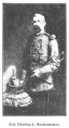
- Wertland Street - the family of William Wertenbaker. Located in the Wertland Street Historic District.[13]

Colonel Wertenbaker was a Civil War veteran, having served in the 19th Virginia Regiment
- West Street - in the neighborhood of 10th and Page, was named for John West, a former slave. A barber by trade, over time West made a substantial return from real estate investments. His house was located in the 300 block (land is now part of the Westhaven development.) [14] West Street is named for an African American.[15]
- Westerly Avenue - unknown
- Westview Road - presumably for the view across the western portion of the 200-acre property owned by Confederate general Thomas L. Rosser and Elizabeth Winston Rosser.
- Westwood Circle - unknown
- Westwood Road - unknown
- Wilder Drive - unknown
- Willard Drive - unknown
- Willow Drive - presumably a botanical name
- Wilson Court - unknown
- Wine Cellar Circle - named for the Monticello Wine Company located at the end of Wine Street, near Hedge Street. Founded in 1873, it was the largest winery in the South.
- Wine Street - named for the Monticello Wine Company located at the end of the street, founded in 1873.
- Winston Road - in the Venable neighborhood, named for Elizabeth Winston, wife of Confederate general Thomas L. Rosser. Winston Rd. and Rosser Ln. intersect at a corner of the block encompassing Rugby Hall, which the Rossers purchased in 1885.
- Winston Terrace - same as Winston Road
- Wise Street - likely Wise County, Virginia and https://en.wikipedia.org/wiki/Henry_A._Wise
- Witton Court - unknown
- Woodfolk Drive - unknown
- Woodland Drive - unknown
- Woodrow Street - unknown
(Y)
- Yorktown Drive - Yorktown, Virginia site of the Siege of Yorktown (1862), the last major battle of the American Revolutionary War. Part of a cluster of names pertaining to American history in the Greenbrier neighborhood.
(Z)
- Zan Road – unknown
Street name changes
- Augusta Road - renamed Rosser Lane. Constructed sometime after 1938, it appeared as August Rd on the 1950 Census Enumeration Map of Charlottesville.[16]
- Azalea Street - renamed to Manila Street to avoid confusion with nearby Azalea Drive
Extinct streets
- Alphanso Street – ran north from Williams Street to Preston W first east of 10th NW
- Apple Street – West of 601 Ridge Street
- Cabell Street – parallel to Lee Street, subsumed by Pinn Hall at UVA Medical Center
- Belmont Avenue (Rose Hill) - now Dale Aveue
- Diggs - removed with the development of Garrett Square (now Friendship Court) (Sanborn Maps)
- Fuller Avenue - renamed as part of Monticello Avenue, when Monticello was "redirected" to continue west instead of turning north on what is now Avon Street (Sanborn Maps)
- Loudoun Road (ca. 1964) – (undeveloped street between Lewis Mountain and Thomson roads)[17]
- Park Place Avenue – perpendicular to Lee Street, subsumed by Pinn Hall at UVA Medical Center
- Parrot - removed with the development of Garrett Square (now Friendship Court) (Sanborn Maps)
- Randall Street – parallel to Lee Street, subsumed by Pinn Hall at UVA Medical Center
- Williams Street - on Sanborn Maps
- Wyndhurst Circle and Wyndhurst Way, ca. 1920; precursors to the present-day Preston Place.[18]
Automobile Blue Book (1919)

References
- ↑ https://babel.hathitrust.org/cgi/pt?id=uva.x000196692&view=1up&seq=33
- ↑ 2.0 2.1 Massie, Frank A., and Virginia School Company. A New and Historical Map of Albemarle County, Virginia. Owned and published by the Virginia School Company, 1907. https://search.lib.virginia.edu/sources/maps/items/u2716440
- ↑ Web. Albemarle County In Virginia, Rev. Edgar Woods, The Michie Company, Printers, 1901, retrieved May 7, 2019.
- ↑ Web. The Cabell Family, University of Virginia Special Collections Library, 2018
- ↑ https://news.virginia.edu/content/do-you-know-history-your-favorite-corner-spots
- ↑ Sheridan R. Barringer, Custer's Gray Rival, (Burlington, NC, 2019), 249.
- ↑ Web. Kenneth R. Crispell, 79, Dean And Health Expert on Presidents, New York Times, Aug. 26, 1996, retrieved 2020-10-14.
- ↑ https://uvamagazine.org/articles/the_golden_age_of_the_rooming_house_matrons
- ↑ Web. [1]
- ↑ Woods, E. (1901). Albemarle County in Virginia: giving some account of what it was by nature, of what it was made by man, and of some of the men who made it. Charlottesville, Va.: The Michie Company, printers. https://www.google.com/books/edition/Albemarle_County_in_Virginia/oX3hxtr5L24C?hl=en
- ↑ http://www2.vcdh.virginia.edu/lewisandclark/students/projects/homesteads/genealogy/meriwethers.html
- ↑ http://ead.lib.virginia.edu/vivaxtf/view?query=Roslyn&docId=uva-sc%2Fviu03696.xml&chunk.id=
- ↑ https://www.dhr.virginia.gov/historic-registers/104-0136/
- ↑ http://www.charlottesville.org/community/neighborhood-connection/10th-and-page
- ↑ http://www.c-ville.com/Rosey_homecoming/
- ↑ Web. 1950 Census Enumeration District Maps - Virginia (VA) - Charlottesville City - Charlottesville - ED 104-1 to 31, US Census Bureau
- ↑ https://v3.lib.virginia.edu/catalog/uva-lib:2681176/view#openLayer/uva-lib:2681197/3799.5/4438.5/4/1/0
- ↑ https://www.dhr.virginia.gov/wp-content/uploads/2018/04/104-0048_Wyndhurst_2018_NR_Summary_Proposed_Relocation.pdf